
Программа лоуренс для андроид
Мы рады сообщить о выпуске нового программного обеспечения Lowrance 20.3 для всех дисплеев HDS Live, HDS Carbon и Elite FS. Также обновление предназначено для модулей эхолокации: Active Target, LiveSight и StructureScan 3D. (Модули эхолокации необходимо обновлять только в том случае, если обновлено программное обеспечение на дисплее. Версии программного обеспечения на дисплеях и модулях должны совпадать)
Обновление программного обеспечения 20.3 предоставляет следующие функции и исправления программного обеспечения:
- Рыболовная карта станции SiriusXM
- ZoneTrack™ и улучшения интерфейса радара
- Панель управления освещением ITC
- Поддержка IP CAM-1
- Панель приборов Honda Eco Mode
- Различные улучшения и исправления программного обеспечения
Рыболовная карта станции SiriusXM
Данные станции SiriusXM предоставляют информацию, необходимую рыболовам, для поиска мест, где с наибольшей вероятностью будет находиться рыба, помогая сэкономить время и топливо.
Станция определяет места в океане, где с наибольшей вероятностью находится рыба. Рыболовная карта предоставляет регулярно обновляемые научно обоснованные данные, которые помогают рыболовам быстрее находить рыбу, экономя время и топливо. Эта услуга включает в себя все погодные данные станции SiriusXM , а также 8 специальных функций для морских рыболовов: рекомендации по рыбалке, линии сорняков, аномалии высоты поверхности моря, изолинии температуры поверхности моря, температура моря на поверхности, температура моря на глубине 30 м, контуры скопления планктона и плотность скопления планктона.
Рыболовная карта — это услуга, доступная по подписке, доступная при использовании погодной станции SiriusXM. Доступно только в тех странах, где поддерживается работа SiriusXM.
Новые функции и улучшения радара
Новые возможности Halo 20/24+
- ZoneTrack™. Автоматическое сопровождение радиолокационных целей в пределах до двух указанных зон
- Ручное наблюдение до 50 целей
- Ассоциация целей РЛС и АИС
Радар: улучшения интерфейса
- Улучшены следы радиолокационных и АИС-целей.
- Изменены символы цели РЛС и АИС.
- Панель радара имеет более выраженную символику (например, кольца компаса и дальности).
- Изменена структура меню панели радара.
- Изменены параметры отслеживания и фильтрации целей РЛС и АИС.
- Отображение маршрутов на радаре PPI
- Новое предупреждение об опасной цели
Поддержка IP CAM-1
Данное программное обеспечения будет поддерживать новую IP CAM-1, представленную во втором квартале 2021 года.
Это новая IP-камера, доступная для Lowrance HDS Live.
Панель управления освещением ITC
Эта версия позволяет управлять световыми эффектами систем освещения ITC.
Если модуль управления освещением ITC установлен и подключен к сети NMEA 2000, панель управления должна быть активирована на МФД.
Панель управления можно активировать / деактивировать в диалоговом окне «Дополнительные настройки».
Режим Honda ECO
- Статус ECO на МФД Lowrance от Honda Engines
- Информация о режиме ECO доступна через соединение NMEA2000.
- Доступен от одной до восьми конфигураций двигателя
Исправления и улучшения
- Нет изображения / пустая панель LiveSight и ActiveTarget, когда МФД подключен к Wi-Fi
- Медленная прокрутка сонара на небольшой глубине
- Значок ActiveTarget Beam перемещен в другое место на панели ActiveTarget
Компания Lowrance®, мировой лидер в производстве рыболовной электроники с 1957 года, на этой неделе официально представила приложение Lowrance® App, включающее набор новых премиальных функций, расширенную функциональность и полную синхронизацию с полным спектром рыбопоисковых эхолотов и картплоттеров Lowrance.
Приложение Lowrance App можно скачать бесплатно, оно предлагает богатые возможности, включая бесплатные актуальные и подробные морские карты C-MAP®, создание и управление всеми вашими личными путевыми точками, маршрутами, треками, а также морскую погоду, важные точки и многое другое.
Приложение позволяет зарегистрировать ваше устройство (устройства) Lowrance, обеспечивая вас новейшим программным обеспечением, руководствами, информацией и советами, относящимися к вашим приборам, а также возможностью синхронизации данных и управления прямо с мобильного устройства. Приложение доступно как в Apple Store для iOS, так и в Google Play для Android.
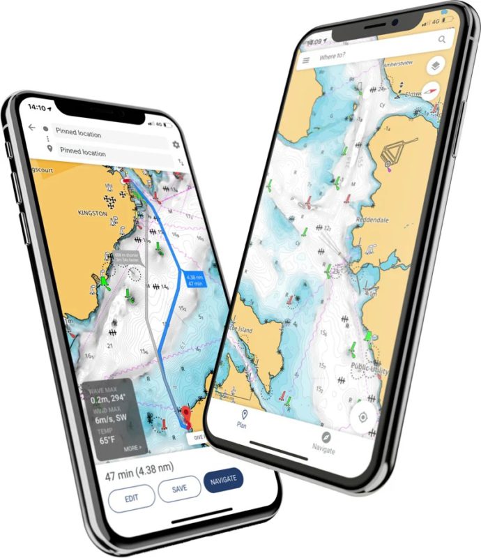
«Возможность управлять, создавать и планировать путевые точки, маршруты и треки в приложении, а затем легко синхронизировать их с дисплеем Lowrance из любой точки лодки. Все эти функции позволят рыболовам проводить больше времени за любимым занятием – рыбалкой», — сказал Лукас Стюард, EVP компании Lowrance. «Независимо от того, пользуетесь ли вы бесплатной или премиум-версией, мы уверены, что все рыболовы будут потрясены подробными картами C-MAP высокого разрешения».
Премиум-версия приложения Lowrance App включает в себя пользовательское затенение глубин — ключевую функцию для рыболовов, а также батиметрические карты высокого разрешения, локальные и глобальные карты, автоматическую идентификационную систему (AIS), Lowrance App Traffic, наложение погоды на 5 дней вдоль маршрута, навигационные данные GPS, запись линии и трека.
«Хотя в премиум-версии предлагается многое, упрощенный вариант «freemium» по-прежнему предоставляет длинный список очень полезных и ценных технологий и функций для рыболовов прямо на ваш смартфон или планшет бесплатно», — добавил Стюард.
Подробные карты C-MAP в приложении тщательно разработаны, чтобы выделить то, что наиболее важно в любой момент времени во время рыбалки, сохраняя точность и чистый, не загромождённый вид в ключевых местах рыбалки для получения максимального опыта рыбалки.

БЕСПЛАТНО
ПРЕМИУМ
• Все, что есть в БЕСПЛАТНОМ, плюс:
• Автономные карты (Глобальная карта)• АИС
• Погода на 5 дней по маршруту
• Навигация: GPS-данные, навигационная линия, запись трека
• Трафик: следите за другими пользователями приложения вокруг
• НОВОЕ: наложение погоды на 5 дней
• НОВОЕ: Батиметрия высокого разрешения
• НОВИНКА: пользовательское затенение глубины


MANAGE YOUR WAYPOINTS

DISCOVER NEW FISHING SPOTS

REVIEW YOUR DATA

SYNC EASILY WITH YOUR DEVICE
Download for free now:
![]()
![]()
With all the latest and most detailed charts from C-MAP ® , the Lowrance App gives you the most accurate charting and layers on a mobile device, allowing you to easily manage your favourite waypoints, discover new fishing spots and plan your next trip in advance. Simply step on board sync your data with your Lowrance device and spend more time fishing, saving any top spots for future trips.
| DETAILED CHARTS | HRB WITH AUTOROUTING | SOCIAL LAYERS | CUSTOM DEPTH SHADING | SHADED RELIEF |
 |  |  |  |  |
DETAILED CHARTS

HRB WITH AUTOROUTING

SOCIAL LAYERS

CUSTOM DEPTH SHADING

SHADED RELIEF

MANAGE AND PLAN
The Lowrance App allows you to create, store, edit and share your waypoints and fishing spots anytime, anywhere. All the tools you need to plan your fishing trips in advance. With offline charts, you can also download your charts to the app and view data even when you are in an area without mobile coverage or WiFi out on the water.


DISCOVER
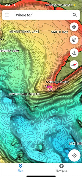
With the Lowrance App, you have all the tools you need to discover new fishing trips and spots in advance. This includes access to the latest C-MAP ® cartography with high-resolution bathymetry charts, custom shading and thousands of Points of Interest, including ramps and fuel near you. You can even use Autorouting™ to set the best routes automatically to your waypoints.
The Lowrance App gives you the freedom and flexibility to save your waypoints, fishing spots and data with your Lowrance devices when you step on board, giving you more time to concentrate on the important stuff, catching more fish!


REVIEW
Simply sync back your app and Lowrance device anytime on or off the water, so you can have all your latest fishing trip data with you at all times.
LATEST C-MAP CHARTS
With high-resolution bathymetry, the maps are carefully crafted to highlight the most important information at any given time and are continuously updated.
CHART PERSONALISATION
Personalize the map to your preferences including chart colourways and detail levels, map rotation, your boat data such as height and depth limits and much more.
WEATHER
Access to exceptional weather data to help you plan but also stay safe on the water including data on sea-state and waves, tides, temperature, precipitation, the moon phase and much more.
AUTOROUTING
The best routing in an app, it lets you plot a route and check your ETA quickly, as well as weather along the route.
POINTS OF INTEREST
Explore thousands of Points of Interest such as ramps, fuel, marinas, harbours, beaches, shops and much more.
MIRRORING AND CONTROL
Mirror and remotely control any connected Lowrance fishfinder through the app, offering the ultimate freedom and control on board.
TRAFFIC
Share your position with friends and family. This feature allows you to be seen and see other app users around you out on the water.
AIS
See boats with class A and B enabled AIS within a 100km radius, as well as their position, speed and course, without sharing your position.
DEVICE HELP & SUPPORT
Register and connect your Lowrance devices to the app and access a library of manuals, guides and how to videos.
MANAGE YOUR WAYPOINTS
DISCOVER NEW FISHING SPOTS
REVIEW YOUR DATA
SYNC EASILY WITH YOUR DEVICE
Download for free now:
![]()
![]()
With all the latest and most detailed charts from C-MAP ® , the Lowrance App gives you the most accurate charting and layers on a mobile device, allowing you to easily manage your favourite waypoints, discover new fishing spots and plan your next trip in advance. Simply step on board sync your data with your Lowrance device and spend more time fishing, saving any top spots for future trips.
| DETAILED CHARTS | HRB WITH AUTOROUTING | SOCIAL LAYERS | CUSTOM DEPTH SHADING | SHADED RELIEF |
| | | | |
DETAILED CHARTS
HRB WITH AUTOROUTING
SOCIAL LAYERS
CUSTOM DEPTH SHADING
SHADED RELIEF
MANAGE AND PLAN
The Lowrance App allows you to create, store, edit and share your waypoints and fishing spots anytime, anywhere. All the tools you need to plan your fishing trips in advance. With offline charts, you can also download your charts to the app and view data even when you are in an area without mobile coverage or WiFi out on the water.
DISCOVER
With the Lowrance App, you have all the tools you need to discover new fishing trips and spots in advance. This includes access to the latest C-MAP ® cartography with high-resolution bathymetry charts, custom shading and thousands of Points of Interest, including ramps and fuel near you. You can even use Autorouting™ to set the best routes automatically to your waypoints.
The Lowrance App gives you the freedom and flexibility to save your waypoints, fishing spots and data with your Lowrance devices when you step on board, giving you more time to concentrate on the important stuff, catching more fish!
REVIEW
Simply sync back your app and Lowrance device anytime on or off the water, so you can have all your latest fishing trip data with you at all times.
LATEST C-MAP CHARTS
With high-resolution bathymetry, the maps are carefully crafted to highlight the most important information at any given time and are continuously updated.
CHART PERSONALISATION
Personalize the map to your preferences including chart colourways and detail levels, map rotation, your boat data such as height and depth limits and much more.
WEATHER
Access to exceptional weather data to help you plan but also stay safe on the water including data on sea-state and waves, tides, temperature, precipitation, the moon phase and much more.
AUTOROUTING
The best routing in an app, it lets you plot a route and check your ETA quickly, as well as weather along the route.
POINTS OF INTEREST
Explore thousands of Points of Interest such as ramps, fuel, marinas, harbours, beaches, shops and much more.
MIRRORING AND CONTROL
Mirror and remotely control any connected Lowrance fishfinder through the app, offering the ultimate freedom and control on board.
TRAFFIC
Share your position with friends and family. This feature allows you to be seen and see other app users around you out on the water.
AIS
See boats with class A and B enabled AIS within a 100km radius, as well as their position, speed and course, without sharing your position.
DEVICE HELP & SUPPORT
Register and connect your Lowrance devices to the app and access a library of manuals, guides and how to videos.
Читайте также: